


Product Description
The Leica RTC series gives modern professionals a faster, more connected way to work.
Built on Leica Geosystems' mastery of 3D laser scanning, the new RTC laser scanners bring together superior scanning performance, software, and cloud collaboration into a real-time workflow architecture, creating a new way of working. Capture high-density 3D data with confidence, share progress as it happens, and keep field, cloud and office users aligned in one continuous workflow.
Leica RTC Series - 3D Laser Scanner Unit Only |
Leica RTC Series - 3D Laser Scanner Subscription Package |
| Leica RTC300, RTC500 or RTC700 3D Laser Scanner | Leica RTC300, RTC500 or RTC700 3D Laser Scanner |
| Leica GEB461 Li-Ion Battery x4 | Leica GST80 Carbon Tripod |
| Leica GVP780 Transport Container | Leica GEB461 Li-Ion Battery x4 |
| Leica 2yr TLS RTC300/500/700 Basic Customer Care Package | Leica GKL341 Charger |
| Leica 2yr Factory Warranty | Leica RTC Raincover |
| Hexagon GeoCloud 500GB 6 Month Trial | Leica GVP781 Backpack |
| Leica GVP780 Transport Container | |
| Leica 1yr Reality Capture Subscription Base | |
| Leica 1yr Cyclone REGISTER 360 PLUS Subscription | |
| Leica 2yr TLS RTC300/500/700 Basic Customer Care Package | |
| Leica 2yr Factory Warranty | |
| Hexagon GeoCloud 500GB 6 Month Trial |
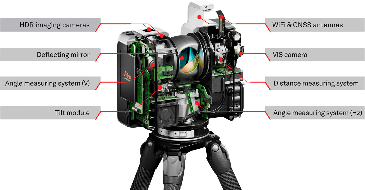
Leica RTC300
The RTC300 delivers trusted Leica RTC performance in a streamlined configuration designed for agile reality capture workflows and growing project demands. Built for professionals working across building construction, BIM, and general surveying applications, it combines high-speed data capture, trusted Leica accuracy, and connected workflows in a scalable platform. Integrated with Leica Cyclone FIELD 360, Hexagon GeoCloud, and Cyclone REGISTER 360 PLUS, it helps simplify field-to-office workflows while reducing revisits and accelerating deliverables.
Leica RTC500
The RTC500 balances speed, range, and operational flexibility for professionals working across surveying, infrastructure, and public safety environments. Designed for versatile reality capture operations, it delivers high-performance scanning, rugged reliability, and connected collaboration workflows that adapt to changing project conditions. Real-time synchronisation between field crews and office teams helps improve coordination, reduce bottlenecks, and accelerate project completion. The RTC500 helps teams capture faster, collaborate more effectively, and deliver with confidence.
Leica RTC700
The RTC700 delivers the highest performance in the RTC portfolio, combining maximum range, exceptional accuracy, and ultra-fast data capture for the most demanding reality capture challenges. Built for industrial facilities, large-scale infrastructure, and complex surveying environments, it enables professionals to capture high-density 3D data with confidence in even the toughest conditions. Advanced connectivity and real-time collaboration workflows enable multiple teams, scanners, and office experts to operate within a single continuous project environment. Designed to reduce downtime, minimise rework, and support large coordinated workflows, the RTC700 helps organisations move from capture to deliverable faster while maintaining the highest standards of precision and reliability.
How Leica RTC can transform your work
Superior Scanning
The Leica RTC series is built for teams that need speed without sacrificing trust in the result. Across all three performance levels, the RTC laser scanners help professionals capture high-density 3D data quickly and reliably in demanding environments.
For construction teams, that means documenting existing conditions and tracking progress without losing momentum on site. For surveyors and infrastructure professionals, it means dependable capture across changing conditions and real project pressure. The outcome is better project control: less rework, more confidence in the data, and a smoother path from the first setup to the final deliverable.
Scalable Performance
As projects grow in size and demand, the RTC software intelligence adapts without disrupting established workflows. From single-scanner operation to multi-scanner, multi-location coordination, the system maintains visibility, alignment, and control.
Remote expertise can guide field execution, teams can connect and collaborate in one continuous data environment, and the increased data volume strengthens clarity rather than creating bottlenecks. Individual accuracy becomes collective performance success.
Real-time Collaboration
Using Livelink in Leica Cyclone FIELD 360, field teams can initiate real-time collaborative projects that make scan data visible beyond the site as it’s captured. Through Hexagon GeoCloud, field and office teams can access and review scan data within the same live project framework.
Registration, quality assurance, quality control, and progress monitoring happen while work is still unfolding, reducing rework, eliminating delays, and enabling earlier decision-making. Once data capture is complete, Leica Cyclone REGISTER 360 PLUS provides powerful post-processing for final registration and validation.
Connected Leica Software Ecosystem
Leica Cyclone FIELD 360
Leica Cyclone FIELD 360 is the mobile field companion for the RTC series designed to simplify scan acquisition, field registration, project visualisation, and on-site collaboration, giving operators immediate visibility into scan data and project progress while still in the field. With intuitive workflows and VIS-assisted registration technology, users can capture, organise, and validate scan data in real time without slowing down operations. FIELD 360 helps reduce complexity for both experienced professionals and newer operators, enabling teams to work more efficiently and leave the job site with greater confidence.
Leica Cyclone REGISTER 360 PLUS
Leica Cyclone REGISTER 360 PLUS helps users register, manage, refine, and deliver high-quality point cloud data efficiently at the office. Integrated directly into the RTC workflow ecosystem, REGISTER 360 PLUS It is designed for fine-tuning point clouds, finalising registration, exporting to nearly any point cloud and data file type, and publishing final reporting on registration work, including errors, overlap, and tolerances.
Hexagon GeoCloud
Hexagon GeoCloud acts as the collaborative backbone of the RTC ecosystem, enabling real-time synchronisation between field crews, office teams, scanners, and cloud-connected workflows. As scan data is captured in the field, project information becomes visible across connected environments, helping teams coordinate activities and make decisions faster. This connected workflow architecture helps eliminate delays between capture and processing while improving operational visibility across large or complex projects.
Product Videos
Videos Hide Videos Show Videos
-

Leica RTC Series - A new dimension in reality capture
The Leica RTC series gives modern professionals a faster, more...
-
Leica RTC300, 500 & 700 Series 3D Laser Scanners
Leica Geosystems Raises the Bar for Reality Capture with the N...
-
Leica RTC Series - Capture, connect, collaborate
Built on Leica Geosystems’ expertise in 3D laser scanning, the...


